
Hair Care
The 8 Best Hiking GPS 2025 – Handheld GPS Devices
Aug
A smartphone is a wonderful hiking companion until cold weather drains its battery, rain turns the touchscreen into an abstract-art generator, or the trail wanders beyond cell coverage. That is where a dedicated hiking GPS earns its space in your backpack.
The best handheld GPS devices are rugged, weather-resistant, readable in direct sunlight, and designed to maintain a satellite connection in forests, mountains, and other places where phones occasionally decide they would rather be cameras. Some models provide detailed topographic maps, while others focus on simple breadcrumb navigation, exceptional battery life, or satellite messaging.
For this 2025 guide, we compared navigation performance, GNSS support, mapping capability, battery life, durability, interface design, portability, emergency communication, and overall value. The Garmin GPSMAP 67i is our best overall choice, but simpler and less expensive models may be better for day hikers, geocachers, and travelers who do not need satellite messaging. Independent field tests have also consistently placed the GPSMAP 67 series among the strongest backcountry navigation devices.
Best Hiking GPS Devices at a Glance
| Device | Best For | Navigation Style | Power | Satellite Messaging |
|---|---|---|---|---|
| Garmin GPSMAP 67i | Best overall | Detailed maps and multi-band GNSS | Rechargeable battery | Yes, with subscription |
| Garmin GPSMAP 67 | Best dedicated hiking GPS | Detailed maps and multi-band GNSS | Rechargeable battery | No |
| Garmin eTrex Solar | Best battery life | Basic navigation and track following | Rechargeable solar-assisted battery | No |
| Garmin Montana 700i | Best large-screen model | Detailed touchscreen mapping | Rechargeable battery | Yes, with subscription |
| Garmin GPSMAP 65s | Best with replaceable batteries | Topo maps and multi-band GNSS | Two AA batteries | No |
| Garmin eTrex 32x | Best affordable color-map GPS | Topo maps and traditional controls | Two AA batteries | No |
| Garmin inReach Mini 2 | Best ultralight safety device | Basic course and breadcrumb navigation | Rechargeable battery | Yes, with subscription |
| Bushnell BackTrack Mini | Best simple backup GPS | Waypoint and return-to-start navigation | Rechargeable battery | No |
How to Choose a Handheld GPS for Hiking
Decide Whether You Need Maps or Breadcrumbs
A full mapping GPS displays trails, contour lines, roads, water features, and saved routes directly on the device. It is the better choice for backpacking, off-trail exploration, hunting, mountaineering, and trips with complicated junctions.
A breadcrumb device records where you have traveled and points toward saved locations. This is useful for returning to a trailhead, campsite, vehicle, or fishing spot, but it does not provide the same geographical context as a topographic map. A direction arrow cannot tell you that the “shortcut” ahead crosses a cliff. Geography remains stubbornly important.
Look for Multi-Band GNSS in Difficult Terrain
Basic receivers use GPS and may also connect to systems such as GLONASS or Galileo. Premium units add multi-band GNSS, allowing the receiver to use multiple signal frequencies. This can produce more consistent tracks around steep canyon walls, tall buildings, and dense tree cover.
Multi-band reception is particularly valuable for hikers who regularly explore mountainous or heavily forested terrain. Casual hikers on open, well-marked trails may not notice enough improvement to justify paying more.
Compare Buttons and Touchscreens
Touchscreens make it easier to pan across a map, enter information, and inspect complicated routes. However, physical buttons generally work better with thick gloves, wet hands, or freezing fingers that have temporarily forgotten how fingers operate.
REI recommends considering screen size, interface preference, advanced sensors, mapping options, and battery type before choosing a receiver. It also advises carrying a map and compass rather than trusting any battery-powered device as your only navigation system.
Understand Satellite Messaging Costs
Devices with Garmin inReach technology can send messages, share location updates, request weather information, and trigger an interactive SOS outside cellular coverage. These communication features generally require activation and a satellite service plan.
Navigation itself may continue to work without a communication subscription, but buyers should calculate the long-term plan cost rather than looking only at the device price.
The 8 Best Hiking GPS Devices for 2025
1. Garmin GPSMAP 67i Best Overall Hiking GPS
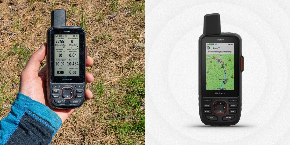
The Garmin GPSMAP 67i combines serious navigation with off-grid communication, making it our top choice for backpackers, guides, hunters, and hikers who regularly travel beyond reliable cell service.
Its multi-band, multi-GNSS receiver is designed to maintain consistent positioning in forests, valleys, and steep terrain. Preloaded TopoActive maps provide roads, trails, elevation details, water features, and useful points of interest. The three-inch color display remains readable outdoors, while physical buttons are dependable in rain and cold weather.
The “i” identifies the model’s integrated inReach technology. With an active satellite plan, users can exchange messages, share their location, obtain forecasts, and contact Garmin’s emergency response service. That integration reduces the number of devices hanging from your shoulder straps like expensive Christmas ornaments.
Garmin rates the battery for up to 165 hours with inReach tracking at 10-minute intervals, up to 180 hours in GPS mode, and up to 840 hours in expedition mode under specified conditions. The device is also rated IPX7 for water resistance.
- Best features: Multi-band accuracy, detailed maps, long battery life, satellite messaging, physical controls.
- Main drawbacks: Premium price, small screen compared with touchscreen models, subscription needed for inReach communication.
- Choose it if: You want navigation and emergency communication in one rugged unit.
2. Garmin GPSMAP 67 Best Dedicated Handheld GPS
The GPSMAP 67 is essentially the navigation-focused sibling of the 67i. It delivers the same general form factor, long battery life, multi-band GNSS support, physical-button interface, and detailed mapping without built-in inReach communication.
For hikers who already own a satellite messengeror simply do not need onethe GPSMAP 67 can be the smarter purchase. There is no need to pay for duplicated emergency hardware or another service plan.
The unit supports TopoActive maps, downloadable satellite imagery, route planning, waypoints, geocaching, elevation data, and wireless synchronization with compatible Garmin apps. It is especially well suited to hikers who want a dedicated GPS rather than a device that relies heavily on a paired phone.
Garmin lists battery life of up to 180 hours in standard GPS mode and up to 840 hours in expedition mode. OutdoorGearLab’s field testing gave the GPSMAP 67 its highest overall ranking, praising its navigation performance and reception in heavily wooded terrain.
- Best features: Excellent reception, long runtime, robust maps, weather-resistant buttons.
- Main drawbacks: No satellite messaging, relatively expensive for a navigation-only device.
- Choose it if: You want premium positioning and mapping without an inReach subscription.
3. Garmin eTrex Solar Best Hiking GPS for Battery Life
The Garmin eTrex Solar is built for hikers who consider charging cables an unnecessary form of emotional baggage. It combines an efficient monochrome display, multi-band satellite reception, USB-C charging, and an integrated solar panel.
Garmin rates it for up to 200 hours in GPS-only mode, up to 100 hours while using multi-band GNSS, and up to 1,800 hours in expedition mode. Under sufficiently bright conditions, solar charging may extend GPS-only operation indefinitely. Actual performance depends on sunlight, settings, temperature, screen use, and how often the device records track points.
The trade-off is mapping detail. This is not a miniature version of the GPSMAP 67. Its compact monochrome screen is better for following a planned course, checking direction, marking waypoints, and recording a track than for studying complicated topography.
It connects with the Garmin Explore app, which makes route planning and trip organization easier. For thru-hikers, bikepackers, and extended travelers who prioritize runtime over rich on-device maps, that compromise can make excellent sense.
- Best features: Exceptional battery life, solar charging, multi-band GNSS, compact construction.
- Main drawbacks: Monochrome display, limited map detail, no satellite SOS.
- Choose it if: Battery anxiety follows you farther than your hiking partners do.
4. Garmin Montana 700i Best Large-Screen Hiking GPS
The Montana 700i is the SUV of handheld navigation devices: large, capable, comfortable to operate, and not especially interested in ultralight backpacking.
Its five-inch glove-friendly touchscreen provides far more map area than the GPSMAP and eTrex models. Panning, zooming, reviewing route alternatives, and reading place names are noticeably easier. The unit includes topographic mapping, navigation tools, an electronic compass, a barometric altimeter, and inReach satellite communication.
Its size makes it especially attractive for overlanding, ATV travel, motorcycling, boating, and trips that combine vehicle navigation with hiking. Compatible powered mounts further strengthen its multi-activity appeal.
The disadvantage is weight and battery duration. Garmin lists more than 18 hours of operation in GPS mode for the Montana 700i, substantially less than the GPSMAP 67 series. It is excellent in a handlebar mount or dashboard cradle but feels rather enthusiastic in a lightweight daypack.
- Best features: Large touchscreen, detailed mapping, vehicle-mount compatibility, inReach communication.
- Main drawbacks: Heavy, bulky, expensive, shorter battery life than smaller premium units.
- Choose it if: Screen size and versatile vehicle-to-trail navigation matter more than pack weight.
5. Garmin GPSMAP 65s Best GPS With Replaceable Batteries
The GPSMAP 65s offers a useful combination of modern positioning technology and old-fashioned AA batteries. That may not sound glamorous, but replaceable batteries are wonderful when the nearest wall outlet is two mountain ranges away.
The device supports multi-band GNSS, preloaded TopoActive maps, a three-axis electronic compass, and a barometric altimeter. Its physical buttons remain dependable with gloves, and the protruding antenna helps provide reliable reception in challenging surroundings.
Battery life is much shorter than that of the newer GPSMAP 67, but hikers can carry spare lithium or rechargeable AA cells and replace them immediately. There is no waiting beside a power bank while your hiking companions make supportive comments about your equipment choices.
Field comparisons have found the GPSMAP 65s capable of delivering strong positioning performance at a lower cost than Garmin’s newest premium handhelds. It does not include inReach messaging, and its older connector and interface feel less modern, but its navigation fundamentals remain highly practical.
- Best features: Multi-band reception, replaceable AA batteries, topo maps, compass and altimeter.
- Main drawbacks: Modest runtime per battery set, older interface, no inReach communication.
- Choose it if: You value field-replaceable power and accurate navigation.
6. Garmin eTrex 32x Best Affordable Color-Map GPS
The eTrex 32x is a proven entry-level handheld for hikers who want real topographic maps without paying premium GPSMAP prices. It has a 2.2-inch color screen, preloaded TopoActive maps, GPS and GLONASS support, a barometric altimeter, and a three-axis compass.
Two AA batteries provide approximately 25 hours of operation under typical conditions, and the device carries an IPX7 water-resistance rating. A microSD card slot allows users to expand map storage.
The eTrex 32x is slower and less intuitive than modern touchscreen devices. Entering names with a small joystick is not difficult, but it may awaken memories of typing text messages on an early flip phone. Its receiver also lacks the multi-band technology found in newer models.
Even so, it remains a sensible choice for marked trails, geocaching, weekend backpacking, and users who prefer replaceable batteries. OutdoorGearLab identified it as a strong value option with enough capability for many recreational users.
- Best features: Color topo maps, compact size, replaceable batteries, compass and altimeter.
- Main drawbacks: Small screen, dated controls, slower map handling, no multi-band reception.
- Choose it if: You want an affordable traditional GPS with proper maps.
7. Garmin inReach Mini 2 Best Ultralight Safety and Navigation Device
The inReach Mini 2 is primarily a satellite communicator, but its GPS tracking, saved courses, waypoints, digital compass, and TracBack routing give it useful navigation capabilities. At roughly 3.5 ounces, it adds far less weight than a full mapping handheld.
With a satellite plan, the Mini 2 supports two-way messaging, location sharing, weather information, and interactive SOS communication over the Iridium satellite network. Garmin rates its battery for up to 14 days with 10-minute tracking and up to 30 days with 30-minute tracking under favorable sky conditions.
Its tiny display is not intended for studying topographic maps. Navigation is best described as course guidance rather than detailed cartography. Pairing it with the Garmin Explore app makes planning and messaging easier, though that introduces some dependence on a smartphone.
This is a particularly strong option for ultralight backpackers who already navigate with a phone and offline maps but want a rugged, independent communication device for emergencies.
- Best features: Very light, global satellite messaging, SOS capability, long battery life, TracBack navigation.
- Main drawbacks: Tiny screen, basic on-device navigation, subscription required for communication.
- Choose it if: Emergency contact and low weight matter more than detailed handheld maps.
8. Bushnell BackTrack Mini Best Simple Backup GPS
The Bushnell BackTrack Mini is designed for straightforward waypoint navigation. It records your path, saves important locations, and helps point you back toward your starting position. It is useful for returning to a parked vehicle, campsite, boat launch, or trailhead.
Its compact body, simple controls, rechargeable battery, and approximately 35-hour claimed runtime make it approachable for beginners. It can also connect to a phone app for reviewing trips and additional information.
However, the BackTrack Mini should not be confused with a detailed topographic navigator. It lacks the mapping depth, sensor package, storage capacity, and route-management tools of premium Garmin handhelds. It works best on uncomplicated outings where the primary objective is finding the way back rather than analyzing every contour line in the county.
- Best features: Simple operation, compact size, rechargeable battery, useful return-to-start guidance.
- Main drawbacks: Limited maps and storage, basic navigation, no satellite communication.
- Choose it if: You need an inexpensive backup device for simple hikes and outdoor activities.
Which Hiking GPS Should You Buy?
Choose the Garmin GPSMAP 67i when you want the strongest all-in-one combination of mapping, multi-band positioning, long battery life, and satellite communication.
Select the GPSMAP 67 when you need premium navigation but already own a satellite messenger. The eTrex Solar is the battery-life champion, while the Montana 700i is the easiest model for viewing and manipulating large maps.
The GPSMAP 65s is ideal for hikers who prefer replaceable AA batteries. The eTrex 32x provides affordable color mapping, and the inReach Mini 2 is the best lightweight choice for communication-focused safety. For basic waypoint guidance and finding your way back, the Bushnell BackTrack Mini covers the essentials.
Field Experience: What Hiking With a Handheld GPS Actually Teaches You
The first lesson a handheld GPS teaches is that preparation matters more than the number of features printed on the box. A premium receiver is not especially useful when the correct map was never downloaded, the planned route was not transferred, and the owner is standing at the trailhead trying to remember a password.
Before a serious hike, create or download the route, inspect it for questionable junctions, and save several strategic waypoints. Useful points include the trailhead, water sources, campsites, major intersections, emergency exits, and the location where the return route separates from the outbound trail. Then confirm that the information is available while the phone is in airplane mode and the GPS has no internet connection.
Battery specifications also deserve realistic interpretation. Laboratory estimates are useful for comparison, but cold temperatures, maximum screen brightness, frequent map checks, wireless connections, and detailed track recording can reduce runtime. A GPS that promises days of operation may still consume power surprisingly quickly when its screen is illuminated every three minutes because someone is wondering whether the summit has moved.
Button-operated units often feel slow at home but become much more appealing during bad weather. Rain can produce accidental touches on a phone, and thick gloves can make a touchscreen frustrating. Physical controls may look old-fashioned, yet they allow a hiker to zoom, change pages, and mark a waypoint without exposing bare fingers to freezing conditions.
Screen size creates another practical trade-off. A larger display makes terrain interpretation easier, particularly where several trails overlap. It also adds weight and consumes more power. On a short day hike, the Montana’s large screen can feel luxurious. On the fourth day of a steep backpacking trip, every extra ounce begins submitting a formal complaint through the shoulder straps.
Satellite messaging requires practice too. Preset check-in messages are faster and more reliable than composing a long note with directional buttons. Create messages such as “Starting the hike,” “Everything is fine,” “Delayed but safe,” and “Finished the route” before leaving home. Explain location-sharing tools to the person monitoring the trip so that a missed check-in has an agreed response rather than immediate panic.
It is equally important to understand what an SOS button does. It begins a real emergency process, not a convenient transportation service for hikers who are tired, hungry, or suddenly opposed to walking downhill. Reserve it for genuine emergencies, keep the device where it can be reached after a fall, and maintain a clear view of the sky when communicating by satellite whenever possible.
Finally, use the GPS as part of a navigation system rather than as the entire system. Carry a paper map and compass, study the route beforehand, observe landmarks, and occasionally compare the electronic position with the surrounding terrain. A hiker who watches only the screen may follow the digital line perfectly while missing an obvious trail signor a considerably more obvious moose.
The best handheld hiking GPS is therefore not merely the model with the longest specification sheet. It is the device you understand, maintain, carry accessibly, and practice using before conditions become difficult.
Conclusion
The handheld GPS market is dominated by Garmin, but the available models serve very different hikers. The GPSMAP 67i is the strongest all-around option for demanding backcountry travel, while the GPSMAP 67 provides similar navigation without satellite communication. Battery-focused travelers should consider the eTrex Solar, and hikers who want replaceable batteries can choose between the GPSMAP 65s and eTrex 32x.
Whatever device you select, test it locally before relying on it in remote terrain. Download maps, save waypoints, learn the controls, check the battery, and carry a traditional navigation backup. Technology is an excellent trail partner, provided it is not expected to do all the thinking.
Note: Manufacturer battery estimates depend on device settings, tracking intervals, temperature, satellite visibility and usage. Satellite messaging and SOS functions may require activation and a paid service plan. Product availability and plan terms should be confirmed before purchase. This guide was synthesized from official specifications and guidance published by Garmin, Bushnell, REI, OutdoorGearLab, GearJunkie, Switchback Travel, Popular Mechanics, HikingGuy, Treeline Review, SFGate, Wired and other established outdoor-technology references.

